The order
EOG requested unitized operations in Cases 32367 and 32368. Corrected Order 35122 identified the spacing units to be terminated. Order 35123 established June 1 as the effective date.
Read the hearing docket ↗
North Dakota · Oil & gas hearings
Find the land described in 7,692 North Dakota hearing orders. This archive reflects the October 29, 2026 research snapshot.
Historical spacing units · 1989–2026
Choose a tract to see its order history, well allowance and available production. Overlapping outlines can represent decisions from different years. Later orders may have changed or terminated a unit.
Drag to pan. Use + or − to zoom and Fit units to return to all matching outlines. With the map focused, use the arrow keys to pan, + or − to zoom, and Home to fit. The unit list also works without a pointer.
Turn off Separate outlines to see the surveyed boundaries. Clicking a location lists every matching tract that contains it, including land between a colored line and the survey edge. Date and record-type colors use the newest matching order for each footprint.
Unit acreage starts with the size in the newest matching order for each outline. Choosing an earlier order updates the selected unit’s color and inset. When the order omits acreage, the map uses 640 nominal acres per whole section. With Separate outlines on, teal 640-acre units sit 600 feet inside the boundary, lime 1,280s sit 450 feet inside, blue 1,920s sit 300 feet inside and orange 2,560s sit 150 feet inside. Larger units are purple. The inset narrows to 60 feet at 3,840 acres and reaches the survey edge at 5,120 acres. Other sizes between those values use a proportional distance.
The view follows the typical north–south and east–west survey lines in western North Dakota. Zoom in to see smaller communities. Town labels use Census place locations. Census TIGERweb places ↗
This historical sample covers Bakken-related hearing orders that describe whole survey sections in a single township. Each outline groups orders for the same sections. Mapped acres measure the outline on the state section map. Stated acres come from the selected order when available. North Dakota survey sections ↗
Horizontal wells allowed is the limit in the selected order for these sections. A qualifier identifies restrictions such as lease-line wells or a particular direction. If we could not attribute a count to this unit in that order, the inspector says so. For three reviewed field examples, a second line gives the number of completed or permitted wells the order reported and the page where it appears.
The filters use the order signing date. A later order can repeat a field rule or terminate a unit. Dates identify the documents in the collection. Check the signed order for the operative rule. DMR field order archive ↗
Alger Field · Mountrail County
Sections 15 and 16 of T156N R92W once formed a 1,280-acre spacing unit. On June 1, 2026, that unit ended as the larger Alger-Bakken (Ross) Unit took effect. The old outline still appears on the historical map.
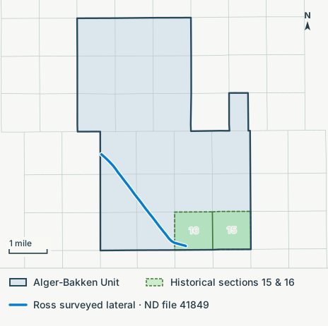
EOG requested unitized operations in Cases 32367 and 32368. Corrected Order 35122 identified the spacing units to be terminated. Order 35123 established June 1 as the effective date.
Read the hearing docket ↗Ross 39-1606H (file 41849) appears in both orders. Its surveyed lateral crosses the old tract, and it was producing before unitization. Its production as first reported is on its well index page.
Follow the well path in 3D →On October 15, the state approved Ross 59-0515H (file 43413) in the Alger-Bakken Unit. The permit places its surface location in Section 5. The site's survey snapshot contains no path for this well.
Read the state permit report ↗Corrected Order 35122 (May 12, 2026), p. 14, ¶1(f)(i), names Ross 39-1606H. Page 16, ¶17, identifies the sections 15–16 spacing unit. Order 35123 (June 29, 2026), pp. 3–4, names the well and gives the unit's effective date. ND field-order archive ↗
The survey record for file 41849 matches API 33-061-05512. Production is reported for the whole well in the free state monthly reports. Production on this site · State monthly reports ↗
Eleven surveyed wells each have at least 660 feet of lateral inside this historical footprint. Inspect those wells in 3D →
Hearing subjects · 2009–2026
Pooling and well spacing account for the largest bands in most years. Each bar counts distinct mapped cases by their latest docket year in the project.
Number of mapped casesShare of each year’s mapped cases
The first year begins February 25, 2009. The last runs through October 22, 2026. “Details pending” covers mapped cases without classifiable request text.
| Year | Pooling | Spacing & well density | Flaring & gas | Injection & storage | Facilities & commingling | Other topics | Details pending | Total |
|---|---|---|---|---|---|---|---|---|
| 2009 | 476 | 362 | 81 | 24 | 1 | 62 | 0 | 1,006 |
| 2010 | 586 | 583 | 42 | 35 | 12 | 105 | 0 | 1,363 |
| 2011 | 680 | 461 | 78 | 48 | 1 | 58 | 0 | 1,326 |
| 2012 | 1,065 | 787 | 155 | 113 | 13 | 97 | 0 | 2,230 |
| 2013 | 964 | 812 | 223 | 65 | 14 | 105 | 0 | 2,183 |
| 2014 | 805 | 761 | 168 | 49 | 14 | 88 | 0 | 1,885 |
| 2015 | 576 | 423 | 92 | 44 | 17 | 56 | 0 | 1,208 |
| 2016 | 382 | 245 | 38 | 47 | 13 | 46 | 0 | 771 |
| 2017 | 350 | 275 | 29 | 59 | 14 | 38 | 0 | 765 |
| 2018 | 356 | 366 | 11 | 66 | 5 | 62 | 0 | 866 |
| 2019 | 433 | 308 | 76 | 70 | 4 | 38 | 0 | 929 |
| 2020 | 180 | 172 | 13 | 40 | 5 | 47 | 12 | 469 |
| 2021 | 212 | 206 | 6 | 29 | 5 | 29 | 1 | 488 |
| 2022 | 302 | 195 | 1 | 34 | 6 | 33 | 21 | 592 |
| 2023 | 414 | 139 | 1 | 53 | 4 | 40 | 197 | 848 |
| 2024 | 400 | 56 | 1 | 42 | 15 | 21 | 264 | 799 |
| 2025 | 451 | 175 | 3 | 55 | 8 | 9 | 238 | 939 |
| 2026 | 204 | 221 | 1 | 64 | 5 | 1 | 406 | 902 |
Hearing cases by subject · 2009–2026
Each mapped case counts once, in the year of its latest docket appearance in the collection.
| Case topic | Cases | Share |
|---|---|---|
| Pooling | 8,836 | 45.2% |
| Spacing & well density | 6,547 | 33.5% |
| Flaring & gas | 1,019 | 5.2% |
| Injection & storage | 937 | 4.8% |
| Facilities & commingling | 156 | 0.8% |
| Other topics | 935 | 4.8% |
| Details pending | 1,139 | 5.8% |
Only cases with a mapped footprint are included. “Details pending” means the project had no request text to classify.
We group each request by the first matching topic in its docket caption. If the caption is blank, we use available request text from a linked order. “Other topics” covers text without a match. These groups describe what a case raised. The signed order records the Commission’s decision.
Pooling combines interests in a spacing unit. Spacing and well density covers unit boundaries, setbacks and the number of wells. Facilities and commingling includes requests to combine production at shared equipment. The injection and storage group also includes unitization and enhanced recovery.
Mapped docket records come from the North Dakota Department of Mineral Resources. Project snapshot, October 29, 2026. DMR GIS downloads · Hearing dockets
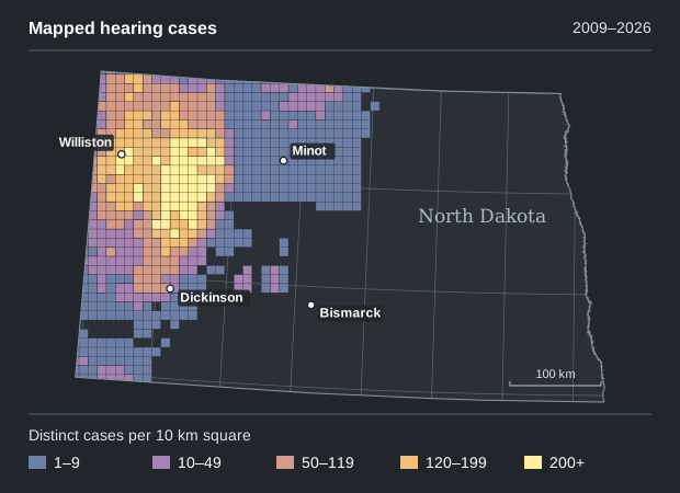
The 19,569 mapped docket cases cluster in western North Dakota. This view counts the cases that overlap each square. Use the spacing-unit map to inspect individual tracts and their order histories.
Pooling orders · January 1–October 21, 2026
Three- and four-section units were the most common. Together they accounted for 189 of the 287 pooling orders with a unit size we could classify.
| Nominal acres | Orders | Share |
|---|---|---|
| 640 | 1 | 0.3% |
| 1,280 | 17 | 5.9% |
| 1,920 | 94 | 32.8% |
| 2,560 | 95 | 33.1% |
| 3,200 | 1 | 0.3% |
| 3,840 | 58 | 20.2% |
| 5,120 | 21 | 7.3% |
One order counts once. Four orders state a matching unit acreage in the Commission’s findings. For 283, we counted the whole sections in the signed pooling clause at 640 nominal acres each. Surveyed acreage can vary.
The signed-order index lists 369 pooling orders in this period, including 314 labeled granted. We matched the case, order number and signing date, then checked the operative clause for a single pooled unit. Of those 314, 27 were left out because the identity, grant or entire unit description could not be reconciled under this rule. Partial sections and mixed land descriptions are outside this whole-section comparison.
Acreage describes the entire spacing unit. An individual owner’s interest may cover only part of it. DMR field order archive (subscription) ↗
Signed hearing orders · 2022–2026
Pooling accounted for about one in ten indexed orders in 2022 and nearly four in ten in 2026. Both figures cover January 1 through October 21, the same window used for every year below.
Number of signed ordersShare of all indexed hearing orders
From the October 2026 snapshot of North Dakota’s Recently Signed Orders index. Each hearing order counts once under its indexed subject, including orders that granted, dismissed or denied a request. The four charts share one scale.
| Indexed subject | 2022 | 2023 | 2024 | 2025 | 2026 |
|---|---|---|---|---|---|
| Pooling | 37 (9.69%) | 101 (24.94%) | 391 (46.38%) | 228 (38.58%) | 369 (39.47%) |
| Amendments | 190 (49.74%) | 144 (35.56%) | 250 (29.66%) | 219 (37.06%) | 346 (37.01%) |
| Commingling | 64 (16.75%) | 82 (20.25%) | 96 (11.39%) | 81 (13.71%) | 90 (9.63%) |
| Saltwater disposal | 22 (5.76%) | 20 (4.94%) | 33 (3.91%) | 28 (4.74%) | 67 (7.17%) |
| Other subjects combined | 69 (18.06%) | 58 (14.32%) | 73 (8.66%) | 35 (5.92%) | 63 (6.74%) |
| All indexed hearing orders | 382 | 405 | 843 | 591 | 935 |
Field decisions
We matched the land descriptions in earlier and later orders. In each of these three Bakken units, the acreage stayed the same while the Commission raised the ceiling for horizontal wells.
Dunn County
1,280 acres · Sections 1 & 2
T148N R97W
1 → 7 wells allowed
The 2026 order identifies one completed well. The application described four additional Middle Bakken wells and two in the Three Forks.
Order 31929, July 29, 2022, p. 10. Order 35872, July 17, 2026, pp. 2, 4–5, 8, 16. Case 32943.
June hearing docket, p. 3 ↗ Map order 35872 →Williams County
1,280 acres · Sections 30 & 31
T156N R101W
1 → 5 wells allowed
Alongside one existing well, the applicant described two alternatives for the same unit. One used two U-shaped wells, the other four straight laterals.
Order 32568, October 13, 2023, p. 11. Order 36005, September 2, 2026, pp. 1–3, 8.
DMR field order archive (subscription) ↗ Map order 36005 →McKenzie & Williams counties
1,920 acres · Sections 3, 10 & 15
T152N R104W
1 → 4 wells allowed
The 2026 order raised the limit to four. A later order repeated that limit, so the project counted the change once.
Order 32530, October 4, 2023, pp. 5, 8. Order 35544, September 11, 2026, pp. 1, 3, 6. Case 32687.
March hearing docket, p. 14 ↗ Map order 35544 →Each pair gives the earlier and later maximum for that specific unit. Actual drilling and completions require separate well records.
Reading the record
Bear Creek · Spacing
XTO asked for up to 15 horizontal wells. The Commission ended two 1,280-acre units and their lease-line overlay, then established a 2,560-acre unit on the same four sections for up to 13 wells.
Case 33188 · Order 36244 · October 19, 2026 · p. 4
Read the docketed request, p. 1 ↗ Map order 36244 →Haystack Butte · Saltwater disposal
The Commission authorized Dakota Fluid Solutions to inject Class II fluids into the Dakota Group through Pendleton #2 SWD, conditional on obtaining and complying with the state injection permit.
Case 33217 · Order 36273 · October 13, 2026 · p. 2
Read the docketed request, p. 11 ↗Research notes
Research snapshot · October 29, 2026
Spacing-unit map. We matched the land descriptions in 7,692 historical orders to 8,779 sections in the North Dakota GIS Hub’s Public Land Survey System layer. The state compiled these boundaries at 1:24,000 scale. We checked each section against the federal survey layer and flagged 29 unit outlines where the sources differ appreciably. The resulting 6,801 outlines cover whole sections within a single township. An order can cover several units, and later orders can restate or terminate earlier rules. Five orders have no usable signing date and appear under All years or Undated.
Cases. We grouped the DMR docketed-case footprints by case number. Of 19,569 mapped cases, 14,193 link to an order whose text the project finished extracting. Repeat docket appearances count once. Cases without a footprint fall outside this view.
Orders. We grouped the signed-order index by hearing-order number, signing date and indexed subject. The five January 1–October 21 windows contain 3,156 distinct hearing orders in total. Administrative orders are excluded. The case and order charts cover different periods and populations.
Field decisions. We checked the specific land descriptions and operative clauses against the signed orders. Page references identify the decision. Public hearing dockets document what applicants requested, and DMR provides the signed files through its subscription archive.