
Inside the viewer
The Bakken in three views.
See how a spacing order reshapes the land, then look closer at the operators and spacing units around individual wells.
Spacing orders
How does an order change the land?
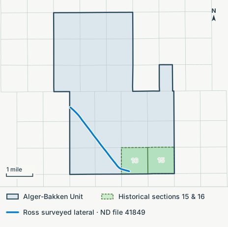
At Alger, orders issued in 2026 placed land that older spacing units covered into the Alger-Bakken Unit. The drawing shows the unit boundary over sections 15 and 16 and the surveyed Ross lateral that crosses it. The spacing-order map shows every order behind it.
Open the spacing-order mapWell paths
Who operates the wells?
Around Williston, wells in the same operator group cluster together. In this snapshot, for example, the legend groups Chord, Enerplus, Oasis, and Whiting together in blue.
Open the screenshot with its legendDrilling spacing units
Which units overlap?
The white outline picks out one 2,560-acre Bakken spacing unit among its neighbors. Follow its edges to see where the footprints overlap. Their vertical placement in this view is approximate.
Open the screenshot with its selection details